
Emily Reserve
Te Rerenga-ora-iti
The historic Emily Reserve across the road is graced by stunning pohutukawa formations but this site was once a formidable point jutting out into the Waitematā harbour at the same height as the Auckland University that sits on the hill behind it, dropping into the sea in sheer cliffs and a strategic stronghold for Māori.
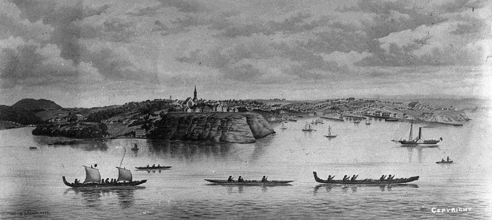
Oil painting by Samuel Stuart showing the Auckland Waterfront with Māori waka and the original St Paul's church beyond Point Britomart, in 1852.)
Also known as Te Rerenga-ora-iti, this place was named by Ngāti Whātua upon their victory of territory at this exact point in 1741. That story is shared below in the video clip below by Ngāti Whātua historian Ngarimu Blair. (2:42 min)
On 18 September 1840, this site became another significant place of transition and marked the spot where an agreement was signed between Ngāti Whātua paramount chief Apihai Te Kawau and Governor Hobson to found the city of Auckland as Tuku Whenua (a strategic gift), an area of approximately 3,000 acres, now roughly the area the city centre. It was here, at Te Rerenga-ora-iti, that a flagpole was raised to mark the auspicious beginning of our nation’s largest and most ethnically diverse city, with the aim of ‘Prosperity in Partnership’.
The great point was eventually quarried away to reclaim land in the area we now know as Britomart near the waterfront, creating the sloping descent of Emily Place as we experience it today. The official memorial e Toka o Apihai Te Kawau and the gift of Tuku Whenua is at 79–75 Quay Street. A short stroll from Emily Place on the way to Queen’s Wharf. Read more
Emily Place has been earmarked for significant streetscape improvements in the near future, highlighting its historical and cultural significance. Learn more here about Emily Place Improvements Project by Auckland Council